
| App Name | GPS Map Camera |
|---|---|
| Latest Version | 1.8.4 |
| Genre | Photography |
| Mod Features | Premium Unlocked |
| Size | 60 MB |
| Update | October 27, 2025 |
| Requires | Android 6.0 |
| Get it On |
|
GPS Map Camera helps users create sharp photos with full details, such as latitude, longitude, and weather. In addition, users can also track each other’s live locations through photos taken from the application.
Get ready to explore the streets and share travel memories with family & friends from GPS Map Camera!
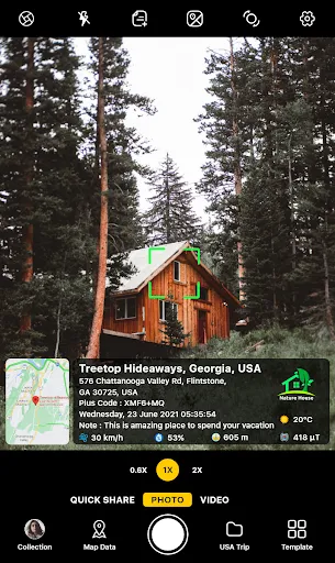
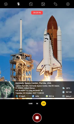
GPS Map Camera helps users quickly take souvenir photos with full details, so users enjoy exploring tourist destinations while having full important information about each photo. Each photo taken contains many important facts (such as time, location, and weather), and users can freely edit the information while keeping the original information package.
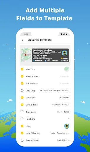
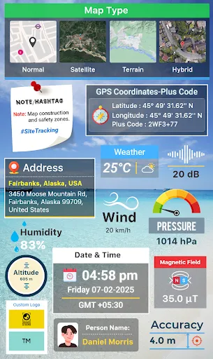
GPS Map Camera helps users express their creativity through personal photo stamps. The application provides a collection of geo-tagging stamps, such as GPS data, map type, and date & time format. Users can choose to use the available stamp templates or create their own personal stamps (unlimited quantity). It is suggested that you combine the necessary icons and fully display the information if you want to create a creative & useful stamp set. In addition, users are free to edit the stamp template with details such as content, size, font size, and font.
Some popular stamp templates include Celebration, Summer, Workout, Traveling… Each stamp template contains different content; for example, the Traveling stamp template displays necessary information such as weather, location, date, and time.
GPS Map Camera provides many different types of information to help make the photo friendly to many different types of viewers. The application allows users to change several types of units, such as temperature (degrees Celsius or Fahrenheit), GPS map (Normal, Satellite, Terrain, Hybrid), and time (12 hours or 24 hours). Because each user has different habits, you should choose the appropriate data type; for example, Vietnamese people use degrees Celsius instead of degrees Fahrenheit.
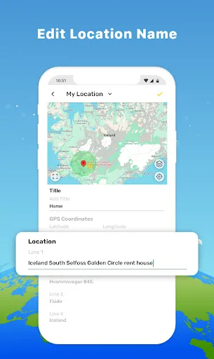
GPS Map Camera provides two ways to display location information on the photo, which are automatic or manual. If you like to edit everything yourself, choose the manual feature, and this allows you to enter all the detailed information related to the location of the photo. If you want to save time, use the automatic location tag feature; the application supports users to find the most accurate location on the GPS map and display location data for the photo after a few seconds.
In summary, GPS Map Camera is an essential photography application for individuals who frequently travel or wish to retain a wealth of useful information in each photo. Each photo is full of important information, so users do not need to worry about information such as the time & location of taking photos.
In addition, the application also allows users to create custom templates with dozens of important information details such as latitude, longitude, date, time, and temperature. Get ready to take interesting travel photos and share them with friends thanks to GPS Map Camera!